
Nimmakuru Fm
Type Locality and Naming
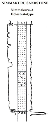
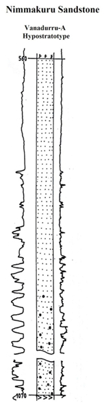
LANDWARD: The type section is in the Well Nimmakuru-A (depth interval: 660-885 m). The hypostratotype is in the Well Vanadurru-A (depth interval:560-1070 m). It was named after the village Nimmakuru by ONGC team steered by Venkatarengan et al. (1993) adopted and issued as Document-VII KDMIPE, ONGC, Dehradun (1993). [Original Publication: Venkatarengan, R., Rao, G.N., Prabhakar, K.N., et al., (1993b) Lithostartigraphy of Petroliferous Basins, Document VIII, Krishna Godavari Basin, KDMIPE, ONGC Publication, pp. 1-29.]. Reference well: Well Vanadurru-A, Interval 560-1070 m and thickness is 510 m.
Synonyms: Nimmakuru Sandstone
[Figure: Generalized Late Cretaceous-Cenozoic lithostratigraphy transect, Krishna-Godavari Basin. From Keller et al., 2011, Jour. Geol. Soc. India, 78:399-428, their Fig. 2]
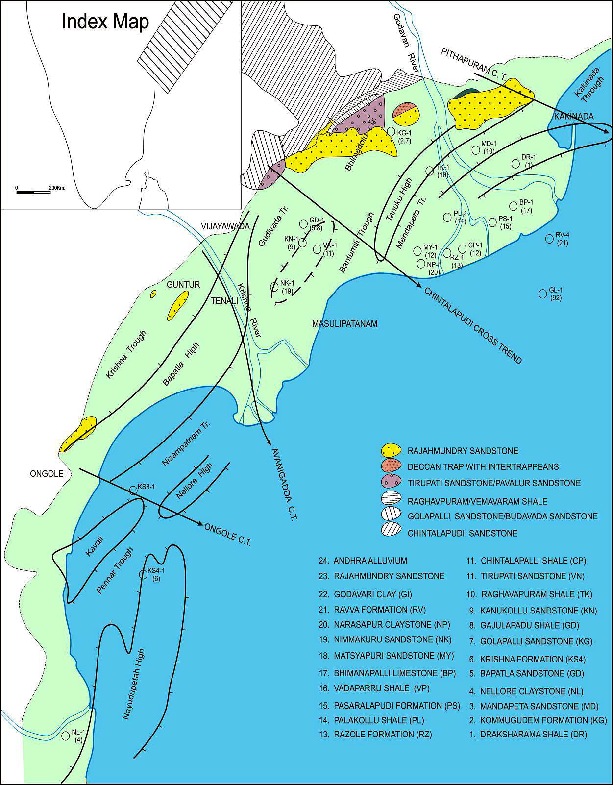
[Figure: Map showing the locations of designated holostratotype section for the formation in the KG Basin (After ONGC, Pandey and Dave, 1998) in Raju et al., 2021, ONGC Bulletin, Special Issue, Vol. 56, No. 2]
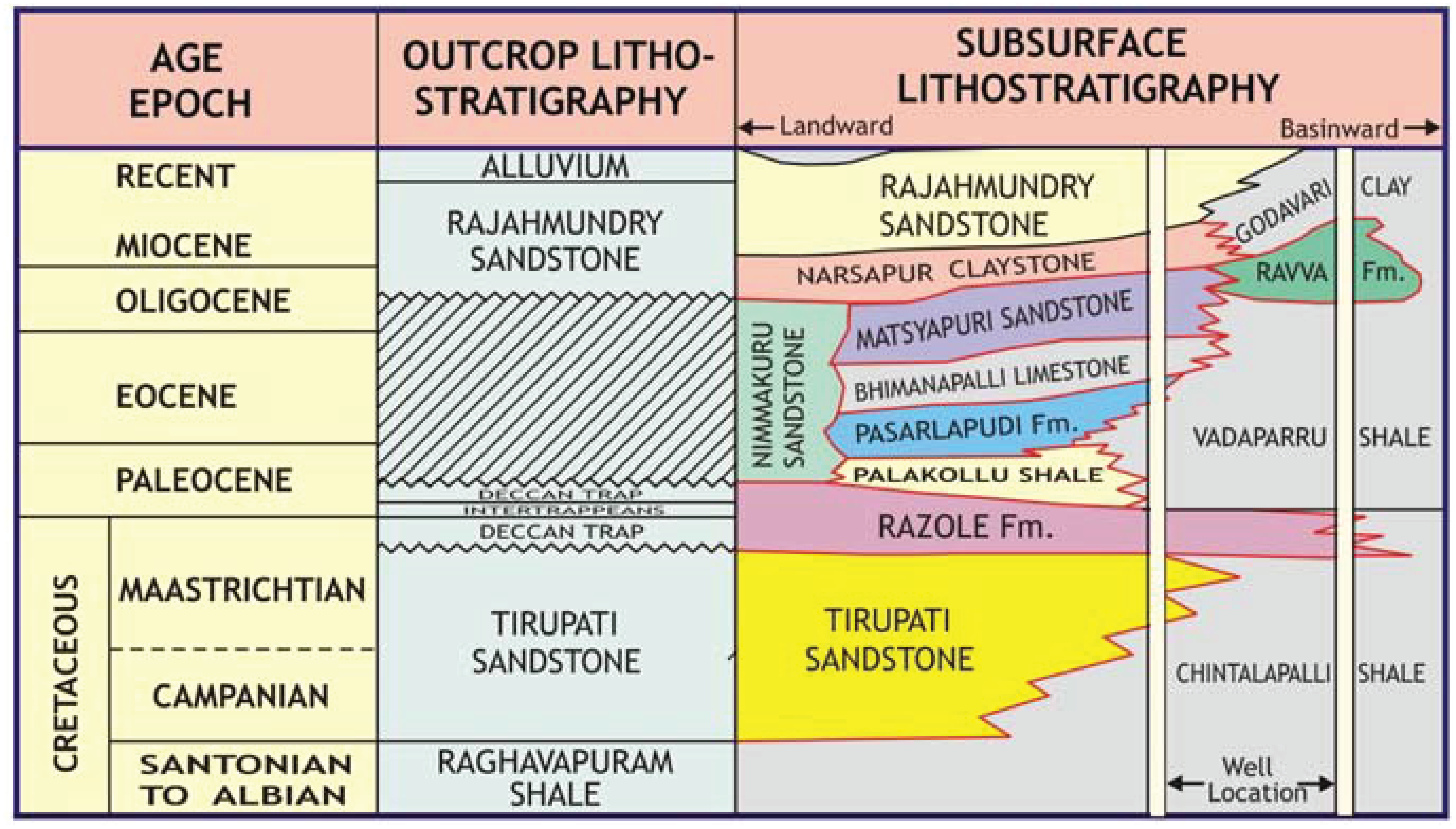
Lithology and Thickness
Coarse-grained sandstone. It is composed dominantly of non-calcareous sandstone with occasional pebbles and claystone. Sandstone is dirty white to white, coarse grained. The claystone is light yellow to brown, soft and non-calcareous. It has a thickness varying from 225-510m.
[Figure 1: Well log of Nimmakuru-A Holostratotype (modified after Venkatarengan et al., 1993)]
[Figure 2: Well log of Vanadurru-A Hypostratotype (modified after Venkatarengan et al., 1993)]
Relationships and Distribution
Lower contact
Unconformable with the Razole Fm (Paleocene) / and locally with Matsyapuri Fm.
Upper contact
Conformable with the Narasapur Fm claystone or Rajahmundry Fm sandstone
Regional extent
It is extensively developed in parts of Krishna-Godavari Basin; but limited to far-landward. Coeval with Matsyapuri Fm and sandstone maybe underlying Bhimanapalli Fm limestone
GeoJSON
Fossils
Age
Depositional setting
Inner-Middle neritic.
Additional Information